Zeitpunkt              Nutzer    Delta   Tröts        TNR     Titel                     Version  maxTL
Mi 02.10.2024 00:00:06    39.522      +1    1.557.686    39,4 ohai.social               4.3.0...   500
Di 01.10.2024 00:15:14    39.521      +3    1.556.181    39,4 ohai.social               4.3.0...   500
Mo 30.09.2024 00:04:59    39.518      +4    1.554.948    39,3 ohai.social               4.3.0...   500
So 29.09.2024 00:14:07    39.514      +3    1.553.524    39,3 ohai.social               4.3.0...   500
Sa 28.09.2024 00:00:38    39.511      +1    1.552.052    39,3 ohai.social               4.3.0...   500
Fr 27.09.2024 00:03:27    39.510       0    1.550.598    39,2 ohai.social               4.3.0...   500
Do 26.09.2024 00:00:23    39.510      +3    1.548.895    39,2 ohai.social               4.3.0...   500
Mi 25.09.2024 00:00:07    39.507       0    1.547.146    39,2 ohai.social               4.3.0...   500
Di 24.09.2024 00:00:29    39.507      +5    1.545.277    39,1 ohai.social               4.3.0...   500
Mo 23.09.2024 00:01:51    39.502       0    1.543.608    39,1 ohai.social               4.3.0...   500
Rob Chapman :ohai: ✍🏼🐧 (@robchapman) · 12/2022 · Tröts: 5.817 · Folger: 205
Mi 02.10.2024 07:37
Good morning peeps :)
I've not been about since Friday, seems like a long time ago.
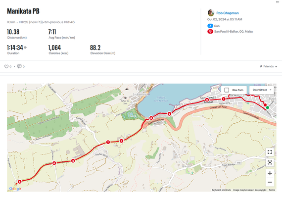
So, my first run of October, and I get a Personal Best for 10km as well...
Honestly, I really wasn't trying for a PB, though I was consciously trying to keep my pace nice and consistent, sort of in a Goldilocks zone...not to fast, not to slow.
Anyway...today's numbers are 10km 1:11:29 (beating my previous best by 2:17) so I'm pretty pumped tbh. 10.38km total distance.
#running #runnersofmastodon #fitness

Image is route map and timing from MapMyRun. The map is called Manikata PB Text below this indicates that this morning i set a personal Best of 1:11:29 (previous best over this distance was 1:13:46) Distance taken 10.38 Avg Pace 7.11 (min/km) Total Duration 1.14.34 Calories (kcal) used 1064 Elavation gain 88.2m Below the text is an open street map of the run for a change, the map uses varying shades of greens, and yellow to indicate the topography, roads are shades of orange, with minor roads and tracks as dotted yellow lines. the running route is marked with a red line, along its length it is marked with numbers from 1 to 10 to show where each km is along the whole course of the route.

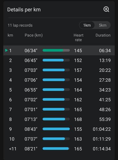
Splits from this mornings 10.38km run 1km - 6.34 2km - 6.45 3km - 7.03 4km - 7.06 5km - 6.55 6km - 7.02 7km - 7.01 8km - 7.13 9km - 8.43 (very steep hill) 10km - 7.07 <11km - 2.05
[Öffentlich] Antw.: 0 Wtrl.: 2 Fav.: 0 · via tooot