Zeitpunkt              Nutzer    Delta   Tröts        TNR     Titel                     Version  maxTL
So 06.10.2024 00:00:03   239.836    +132   18.145.375    75,7 Mastodon 🐘                4.3.0...   500
Sa 05.10.2024 00:00:05   239.704    +152   18.133.601    75,6 Mastodon 🐘                4.3.0...   500
Fr 04.10.2024 00:00:00   239.552    +164   18.129.426    75,7 Mastodon 🐘                4.3.0...   500
Do 03.10.2024 00:00:03   239.388    +136   18.115.749    75,7 Mastodon 🐘                4.3.0...   500
Mi 02.10.2024 00:00:14   239.252    +136   18.099.883    75,7 Mastodon 🐘                4.3.0...   500
Di 01.10.2024 00:00:12   239.116    +122   18.086.174    75,6 Mastodon 🐘                4.3.0...   500
Mo 30.09.2024 00:00:08   238.994    +112   18.073.417    75,6 Mastodon 🐘                4.3.0...   500
So 29.09.2024 00:01:07   238.882    +104   18.062.094    75,6 Mastodon 🐘                4.3.0...   500
Sa 28.09.2024 00:00:15   238.778    +101   18.049.848    75,6 Mastodon 🐘                4.3.0...   500
Fr 27.09.2024 00:00:43   238.677       0   18.054.318    75,6 Mastodon 🐘                4.3.0...   500
Lisa Marie ☮️&💜 (@copacetic_vibe) · 11/2022 · Tröts: 1.639 · Folger: 105
So 06.10.2024 16:16
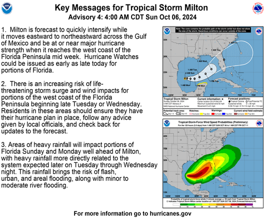
Key Messages for #TropicalStorm #Milton
Advisory 4: 4:00 AM CDT Sun Oct 06, 2024
For more information go to hurricanes.gov
#Weather #Hurricane #Gulf #FLwx

1. Milton is forecast to quickly intensify while it moves eastward to northeastward ačross the Gulf of Mexico and be at or near major hurricane strength when it reaches the west coast of the Florida Peninsula mid week. Hurricane Watches could be issued as early as late today for portions of Florida. 2. There is an increasing risk of life- threatening storm surge and wind impacts for portions of the west coast of the Florida Peninsula beginning late Tuesday or Wednesday. Residents in these areas should ensure they have their hurricane plan in place, follow any advice given by local officials, and check back for updates to the forecast. 3. Areas of heavy rainfall will impact portions of Florida Sunday and Monday well ahead of Milton, with heavy rainfall more directly related to the system expected later on Tuesday through Wednesday night. This rainfall brings the risk of fiash, urban, and areal flooding, along with minor to moderate river flooding
[Öffentlich] Antw.: 0 Wtrl.: 0 Fav.: 0 · via Tusky