Zeitpunkt              Nutzer    Delta   Tröts        TNR     Titel                     Version  maxTL
Do 11.07.2024 00:00:00   191.520       0    9.151.853    47,8 Mastodon                  4.3.0...   500
Mi 10.07.2024 00:00:02   191.520      -1    9.143.378    47,7 Mastodon                  4.3.0...   500
Di 09.07.2024 00:00:00   191.521     -19    9.133.920    47,7 Mastodon                  4.3.0...   500
Mo 08.07.2024 00:00:04   191.540      +1    9.125.263    47,6 Mastodon                  4.3.0...   500
So 07.07.2024 00:00:02   191.539     -34    9.116.590    47,6 Mastodon                  4.3.0...   500
Sa 06.07.2024 00:00:02   191.573      -2    9.109.015    47,5 Mastodon                  4.3.0...   500
Fr 05.07.2024 00:00:04   191.575      -2    9.101.575    47,5 Mastodon                  4.3.0...   500
Do 04.07.2024 00:00:00   191.577      -2    9.092.066    47,5 Mastodon                  4.3.0...   500
Mi 03.07.2024 00:00:00   191.579      -2    9.082.513    47,4 Mastodon                  4.3.0...   500
Di 02.07.2024 00:00:03   191.581       0    9.073.920    47,4 Mastodon                  4.3.0...   500
Pepijn (@Pepijn) · 04/2022 · Tröts: 2.771 · Folger: 695
Do 11.07.2024 11:27
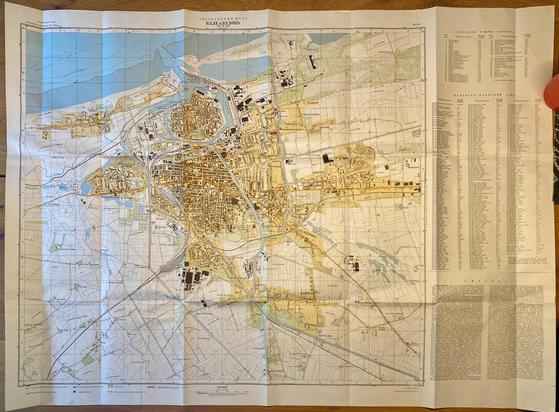
2-x This is a little thread about the #Soviet military mapping project of, frankly, the world. Starting in the 1930s the Soviets made a solid effort to create maps of their own territory. After the death of Stalin (1953) the rest of the world followed.
This effort produced maps from 1:500.000 scale all the way to detailed 1:10.000 maps of individual cities (attached photo is the French city of Calais).
Fyi. I'll put a bunch of nice (online) reference reads at the end of this thread.

Soviet map of Calais. 1:10.000 Data is probably around late 1960s and the latest update would've been collected / checked both in-person (important enough city) and aided by commercially available French maps
[Öffentlich] Antw.: 0 Wtrl.: 0 Fav.: 0