Zeitpunkt              Nutzer    Delta   Tröts        TNR     Titel                     Version  maxTL
So 11.08.2024 00:00:10   191.103       0    9.425.637    49,3 Mastodon                  4.3.0...   500
So 11.08.2024 00:00:10   191.103      -1    9.425.637    49,3 Mastodon                  4.3.0...   500
Sa 10.08.2024 00:00:00   191.104      -2    9.416.737    49,3 Mastodon                  4.3.0...   500
Fr 09.08.2024 00:00:01   191.106      -3    9.414.271    49,3 Mastodon                  4.3.0...   500
Do 08.08.2024 00:00:03   191.109      -6    9.404.365    49,2 Mastodon                  4.3.0...   500
Mi 07.08.2024 00:00:03   191.115      -1    9.397.002    49,2 Mastodon                  4.3.0...   500
Di 06.08.2024 00:00:03   191.116    -167    9.390.529    49,1 Mastodon                  4.3.0...   500
Mo 05.08.2024 00:00:05   191.283     -32    9.381.093    49,0 Mastodon                  4.3.0...   500
So 04.08.2024 00:00:02   191.315      -3    9.372.708    49,0 Mastodon                  4.3.0...   500
Sa 03.08.2024 00:00:00   191.318       0    9.364.577    48,9 Mastodon                  4.3.0...   500
Anne Ominous (@rustoleumlove) · 04/2022 · Tröts: 8.588 · Folger: 574
So 11.08.2024 03:06
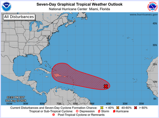
Tropics are cooking something up again
* Formation chance through 48 hours...medium...50 percent.
* Formation chance through 7 days...high...90 percent.
more info: https://www.nhc.noaa.gov/
#TropicalStorm #hurricane #wx #weather

Tropical Weather Outlook NWS National Hurricane Center Miami FL 800 PM EDT Sat Aug 10 2024 For the North Atlantic...Caribbean Sea and the Gulf of Mexico: 1. Near the Lesser and Greater Antilles (AL98): Shower and thunderstorm activity is showing some signs of organization in association with a tropical wave located roughly midway between the Cabo Verde Islands and the Lesser Antilles. Environmental conditions appear conducive for gradual development of this system during the next few days while it moves westward to west-northwestward at 15 to 20 mph across the central tropical Atlantic. A tropical depression is likely to form by the early to middle part of next week while the system approaches and then moves near or over the Lesser Antilles, and interests there should monitor the progress of this system. Then, the system is forecast to move generally west-northwestward and could approach portions of the Greater Antilles by the middle to latter part of next week. * Formation chance through 48 hours...medium...50 percent. * Formation chance through 7 days...high...90 percent.
[Öffentlich] Antw.: 0 Wtrl.: 0 Fav.: 0