Zeitpunkt              Nutzer    Delta   Tröts        TNR     Titel                     Version  maxTL
Sa 05.10.2024 00:00:05   190.332      -1    9.905.211    52,0 Mastodon                  4.3.0...   500
Fr 04.10.2024 00:00:00   190.333      -1    9.887.498    51,9 Mastodon                  4.3.0...   500
Do 03.10.2024 00:00:03   190.334      -2    9.878.838    51,9 Mastodon                  4.3.0...   500
Mi 02.10.2024 00:00:06   190.336      -2    9.870.374    51,9 Mastodon                  4.3.0...   500
Di 01.10.2024 00:00:07   190.338      -3    9.863.625    51,8 Mastodon                  4.3.0...   500
Mo 30.09.2024 00:00:08   190.341      -3    9.853.351    51,8 Mastodon                  4.3.0...   500
So 29.09.2024 00:00:03   190.344      +1    9.843.604    51,7 Mastodon                  4.3.0...   500
Sa 28.09.2024 00:00:03   190.343      -4    9.834.146    51,7 Mastodon                  4.3.0...   500
Fr 27.09.2024 00:00:02   190.347      -2    9.824.358    51,6 Mastodon                  4.3.0...   500
Do 26.09.2024 00:00:00   190.349       0    9.813.984    51,6 Mastodon                  4.3.0...   500
Anne Ominous (@rustoleumlove) · 04/2022 · Tröts: 9.141 · Folger: 593
Sa 05.10.2024 19:29
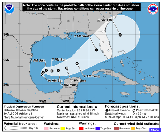
another storm is firing up and taking aim at the Guld Coast of Florida (might become #Milton in a few days)
#hurricane #wx #weather #Florida #TropicalStorm #ExtremeWeather

Key Messages: 1. The depression is forecast to quickly intensify while it moves eastward to northeastward across the Gulf of Mexico and be at or near major hurricane strength when it reaches the west coast of the Florida Peninsula mid week. 2. There is an increasing risk of life-threatening storm surge and wind impacts for portions of the west coast of the Florida Peninsula beginning late Tuesday or Wednesday. Residents in these areas should ensure they have their hurricane plan in place, follow any advice given by local officials, and check back for updates to the forecast. 3. Areas of heavy rainfall will impact portions of Florida Sunday and Monday well ahead of the tropical system, with heavy rainfall more directly related to the system expected by later Tuesday through Wednesday. This rainfall brings the risk of flash, urban, and areal flooding, along with minor to isolated moderate river flooding.
[Öffentlich] Antw.: 0 Wtrl.: 1 Fav.: 0