Zeitpunkt              Nutzer    Delta   Tröts        TNR     Titel                     Version  maxTL
Sa 29.06.2024 00:00:03   191.877      -2    9.048.452    47,2 Mastodon                  4.3.0...   500
Fr 28.06.2024 00:00:02   191.879       0    9.047.750    47,2 Mastodon                  4.3.0...   500
Do 27.06.2024 00:00:02   191.879      -3    9.040.276    47,1 Mastodon                  4.3.0...   500
Mi 26.06.2024 00:00:02   191.882      -3    9.034.026    47,1 Mastodon                  4.3.0...   500
Di 25.06.2024 00:00:02   191.885      -2    9.024.989    47,0 Mastodon                  4.3.0...   500
Mo 24.06.2024 00:00:06   191.887      -2    9.016.534    47,0 Mastodon                  4.3.0...   500
So 23.06.2024 00:00:01   191.889      -2    9.009.760    47,0 Mastodon                  4.3.0...   500
Sa 22.06.2024 00:00:04   191.891      -2    9.002.919    46,9 Mastodon                  4.3.0...   500
Fr 21.06.2024 00:00:04   191.893      -2    8.993.668    46,9 Mastodon                  4.3.0...   500
Do 20.06.2024 00:00:03   191.895       0    8.984.664    46,8 Mastodon                  4.3.0...   500
Dismal Manor Gang (@DismalManorGang) · 04/2022 · Tröts: 4.070 · Folger: 497
Sa 29.06.2024 12:01
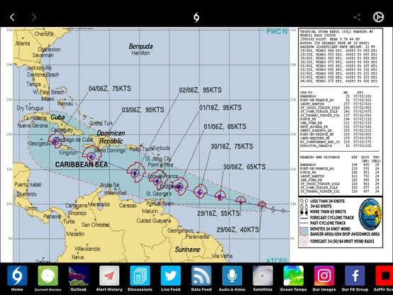
TD2 is Hurricane Beryl Saturday morning. Low shear conditions permit rapid development as the storm crosses the Carribian. Doc Cowan’s brief explains the interaction with the islands including intensify and track variation.
It is likely the storm will enter the gulf of Mexico late next week and hold coastal and offshore interests at risk.
The chart shows best estimate track, intensify and storm size.
Onset time and rainfall also shown #TropicalWx #severewx

The wind hazard heat map with onset date and time bands added.

Rainfall guidance showing where excessive rainfall is likely and estimated rainfall accumulation.
[Öffentlich] Antw.: 0 Wtrl.: 0 Fav.: 0 · via Ivory for iOS