Zeitpunkt              Nutzer    Delta   Tröts        TNR     Titel                     Version  maxTL
Do 11.07.2024 00:00:00   191.520       0    9.151.853    47,8 Mastodon                  4.3.0...   500
Mi 10.07.2024 00:00:02   191.520      -1    9.143.378    47,7 Mastodon                  4.3.0...   500
Di 09.07.2024 00:00:00   191.521     -19    9.133.920    47,7 Mastodon                  4.3.0...   500
Mo 08.07.2024 00:00:04   191.540      +1    9.125.263    47,6 Mastodon                  4.3.0...   500
So 07.07.2024 00:00:02   191.539     -34    9.116.590    47,6 Mastodon                  4.3.0...   500
Sa 06.07.2024 00:00:02   191.573      -2    9.109.015    47,5 Mastodon                  4.3.0...   500
Fr 05.07.2024 00:00:04   191.575      -2    9.101.575    47,5 Mastodon                  4.3.0...   500
Do 04.07.2024 00:00:00   191.577      -2    9.092.066    47,5 Mastodon                  4.3.0...   500
Mi 03.07.2024 00:00:00   191.579      -2    9.082.513    47,4 Mastodon                  4.3.0...   500
Di 02.07.2024 00:00:03   191.581       0    9.073.920    47,4 Mastodon                  4.3.0...   500
Pepijn (@Pepijn) · 04/2022 · Tröts: 2.772 · Folger: 696
Do 11.07.2024 11:48
3-x These maps were regularly updated. That doesn't say each map is always fully up-to-date as it takes a lot to map the world.
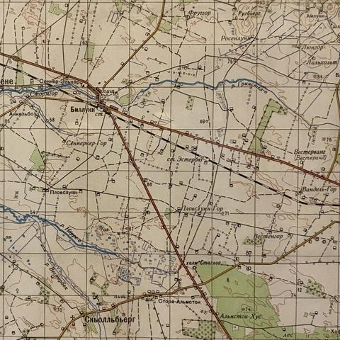
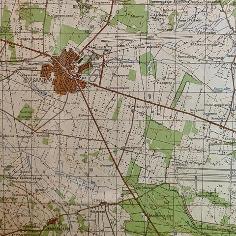
Here are two versions of the same 1:50.000 map. It's my home area of Billund, Denmark. The map is accurate to include individual houses (not their exact outlines).
The first map shows the situation before WW2. In ww2 an airport was constructed, and later LEGO constructed another one (top middle). The second map is from the 1970s.
Some additional info in the ALT text.

pre-ww2 situation. Billund (top left where the roads meet) is a tiny town. There's still a railroad. Overal detail is low and mapping is somewhat primative: lines are thick, corners are rounded to obfuscate inaccuracies.

The later map. It appears to be a rebuild map and just not an iteration on the older map. The railroad is gone but we now have two airports. It also accurately showes power lines, hedgerows and land use. There is very accurate detailing of water sheds in this map. It's just a bit more extensive than any danish map of the same ago I have been able to find. As I suspect this part of the map was copied from somewhere any insight in that is welcome.
[Öffentlich] Antw.: 0 Wtrl.: 0 Fav.: 0