Zeitpunkt              Nutzer    Delta   Tröts        TNR     Titel                     Version  maxTL
So 04.08.2024 00:00:02   191.315      -3    9.372.708    49,0 Mastodon                  4.3.0...   500
Sa 03.08.2024 00:00:00   191.318      -1    9.364.577    48,9 Mastodon                  4.3.0...   500
Fr 02.08.2024 00:00:03   191.319      -1    9.355.247    48,9 Mastodon                  4.3.0...   500
Do 01.08.2024 00:00:07   191.320       0    9.345.588    48,8 Mastodon                  4.3.0...   500
Mi 31.07.2024 00:00:02   191.320      -2    9.336.598    48,8 Mastodon                  4.3.0...   500
Di 30.07.2024 00:00:03   191.322      -8    9.327.492    48,8 Mastodon                  4.3.0...   500
Mo 29.07.2024 00:00:00   191.330      -1    9.318.622    48,7 Mastodon                  4.3.0...   500
So 28.07.2024 00:00:03   191.331       0    9.309.563    48,7 Mastodon                  4.3.0...   500
Sa 27.07.2024 00:00:04   191.331       0    9.300.691    48,6 Mastodon                  4.3.0...   500
Fr 26.07.2024 00:00:03   191.331       0    9.290.684    48,6 Mastodon                  4.3.0...   500
FunGuy2PlayWith (@funguy2playwith) · 11/2022 · Tröts: 6.421 · Folger: 163
So 04.08.2024 20:21
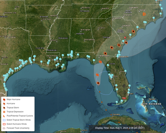
This is a very useful interactive map (NOAA Coastal Inundation Dashboard) with real-time coastal conditions:
#TropicalStormDebbie #NOAA
https://tidesandcurrents.noaa.gov/inundationdb/

Interactive Map of the South Eastern US highlighting Tropical Storm Debbie projected path with NOS Station pins which identify various coastal measurements. For example: Cedar Key, FL (8727520) Present Water Level 2024-08-04 02:06 PM 1.74 Latest Wind Speed (kts) 2024-08-04 02:00 PM 19.1 Latest Barometric Pressure (mb) 2024-08-04 02:00 PM 1010.1 Next High Tide 2024-08-04 02:10 PM 0.36 Highest Tomorrow 2024-08-05 02:53 PM 0.3 https://tidesandcurrents.noaa.gov/inundationdb/
[Öffentlich] Antw.: 0 Wtrl.: 0 Fav.: 0 · via Web