Zeitpunkt              Nutzer    Delta   Tröts        TNR     Titel                     Version  maxTL
Fr 05.07.2024 00:00:27    61.919       0    3.520.710    56,9 Fosstodon                 4.2.10     500
Do 04.07.2024 00:00:52    61.919      +2    3.517.337    56,8 Fosstodon                 4.2.9      500
Mi 03.07.2024 00:00:12    61.917      +2    3.513.906    56,8 Fosstodon                 4.2.9      500
Di 02.07.2024 00:01:44    61.915      -2    3.510.479    56,7 Fosstodon                 4.2.9      500
Mo 01.07.2024 00:00:33    61.917       0    3.507.420    56,6 Fosstodon                 4.2.9      500
So 30.06.2024 00:00:34    61.917      +2    3.504.671    56,6 Fosstodon                 4.2.9      500
Sa 29.06.2024 00:01:13    61.915      +2    3.501.982    56,6 Fosstodon                 4.2.9      500
Fr 28.06.2024 00:01:07    61.913      +3    3.498.459    56,5 Fosstodon                 4.2.9      500
Do 27.06.2024 00:00:32    61.910       0    3.495.444    56,5 Fosstodon                 4.2.9      500
Mi 26.06.2024 00:00:07    61.910       0    3.494.703    56,4 Fosstodon                 4.2.9      500
Matthieu Viry (@mthv) · 11/2022 · Tröts: 102 · Folger: 299
Fr 05.07.2024 10:54
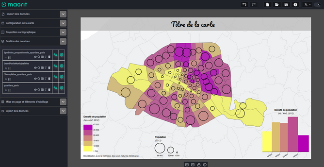
📢 #Magrit v2.0.0, a new major release of our thematic cartography application, is now available!
Some key features are:
- New functionalities (aggregation, selection, simplification, KDE, linear regression, etc.)
- Privacy-friendly (all your data remains in the browser)
- A stand-alone version is available for offline use.
🔗 App and documentation: https://magrit.cnrs.fr/
🔗 Github repository: https://github.com/riatelab/magrit

Screenshot of the Magrit interface (using dark theme) while creating a thematic map. This shows the outline of Paris city districts, colored according to population density, transparent proportional symbols to represent the population stock per district, and various legend elements.
[Öffentlich] Antw.: 0 Wtrl.: 0 Fav.: 0