Zeitpunkt              Nutzer    Delta   Tröts        TNR     Titel                     Version  maxTL
Mo 07.10.2024 00:00:05     9.926      -1      606.345    61,1 Climate Justice Social    4.2.1... 5.000
So 06.10.2024 00:00:13     9.927      +2      605.966    61,0 Climate Justice Social    4.2.1... 5.000
Sa 05.10.2024 00:00:29     9.925       0      605.309    61,0 Climate Justice Social    4.2.1... 5.000
Fr 04.10.2024 00:01:13     9.925      +2      604.544    60,9 Climate Justice Social    4.2.1... 5.000
Do 03.10.2024 00:00:13     9.923       0      603.966    60,9 Climate Justice Social    4.2.1... 5.000
Mi 02.10.2024 00:00:06     9.923       0      603.120    60,8 Climate Justice Social    4.2.1... 5.000
Di 01.10.2024 00:00:15     9.923       0      602.318    60,7 Climate Justice Social    4.2.1... 5.000
Mo 30.09.2024 00:01:14     9.923       0      601.459    60,6 Climate Justice Social    4.2.1... 5.000
So 29.09.2024 00:01:08     9.923       0      600.812    60,5 Climate Justice Social    4.2.1... 5.000
Sa 28.09.2024 00:01:08     9.923       0      600.059    60,5 Climate Justice Social    4.2.1... 5.000
Bread and Circuses (@breadandcircuses) · 11/2022 · Tröts: 4.182 · Folger: 9.892
Mo 07.10.2024 14:00
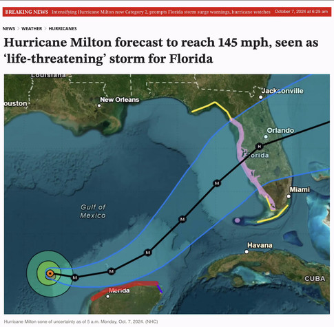
If you're anywhere near the projected track of Hurricane Milton, please start preparing immediately. Stay safe!
From the Orlando Sentinel...
➡️ https://www.orlandosentinel.com/2024/10/07/intensifying-hurricane-milton-now-category-2-prompts-florida-storm-surge-warnings-hurricane-watches/
___________________________
Hurricane Milton continued to strengthen early Monday hitting 125 mph sustained winds making it a major Category 3 storm on its way to an expected landfall on Florida’s Gulf Coast.
“Further strengthening is expected, and Milton is forecast to become an extremely dangerous Category 4 hurricane later today and maintain that intensity for the next couple of days,” said NHC senior hurricane specialist Eric Blake.
“The system is likely to be a large and powerful hurricane at landfall in Florida, with life-threatening hazards,” said NHC senior hurricane specialist Jack Beven.
___________________________
From the Sarasota Herald-Tribune...
➡️ https://www.heraldtribune.com/story/weather/hurricane/2024/10/07/hurricane-milton-spaghetti-models-forecast-path-impacts-watches-warnings-landfall/75547053007/
___________________________
Hurricane Milton continues to strength over the Gulf of Mexico as it takes aim at Florida, according to a special advisory from the National Hurricane Center.
At 7 a.m., forecasters issued a special update, saying Milton is now a Category 3 hurricane with maximum sustained winds of 120 mph.
Hurricane watches and storm surge watches have now been expanded for portions of Florida ahead of what is expected to become a major hurricane. Devastating impacts are forecast for Florida, from life-threatening storm surge, flooding rain and damaging winds.
A state of emergency has been declared in Florida for 51 out of 67 counties ahead of Milton, which is taking aim at the western coast of the state. Milton is expected to make landfall Wednesday.
"Despite uncertainty about exactly how Milton plays out, there is high confidence that a destructive surge is coming to Southwest Florida on Wednesday, with the potential for the worst surge in more than 100 years in the Tampa Bay area," said Florida meteorologist Dr. Ryan Truchelut.
#Florida #Hurricane #Science #Environment #Climate #ClimateChange #ClimateCrisis

Screenshot from article in the Orlando Sentinel. Headline says: "Hurricane Milton forecast to reach 145 MPH, seen as life-threatening storm for Florida." Below this is a graphic showing projected track of the storm as it moves across the Gulf of Mexico toward Florida.
[Öffentlich] Antw.: 0 Wtrl.: 7 Fav.: 4 · via Web